Soil moisture at very high resolution
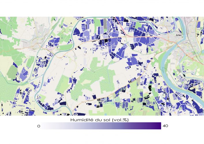
The “Soil moisture with very high spatial resolution” SEC offers soil moisture maps with frequent repetition (a map every six days) at the sub-parcel scale on several sites in France, in Europe and around the Mediterranean basin.
Algorithms were developed and moisture maps produced with the support of IRSTEA (UMR TETIS) and CNES (TOSCA Project). This work was carried out in close collaboration with Mehrez Zribi at CESBIO.
The data used come from the Sentinel-1 radar and Sentinel-2 optical Copernicus image series. The radar signal inversion algorithm uses neural networks. It is applied to agricultural parcels (with or without vegetation) extracted from the 2016 and 2017 land cover maps produced by the Theia Land Cover SEC (Jordi Inglada et al., CESBIO).
Sentinel-2 images were used to calculate the NDVI (normalized difference vegetation index). This index is a necessary input for the inversion algorithm, both in order to divide the agricultural areas resulting from the land cover map and to simulate the contribution of vegetation to the total radar signal received by the satellite. Segmentation allows homogeneous polygons inside agricultural parcels to be extracted, and, as a result, allows objects to be offered that are finer than the outline of the parcels.
Thanks to a large field campaign close to the city of Montpellier (almost 500 in situ measurements), the precision for the soil moisture estimate reaches 6 vol.%.
Data description
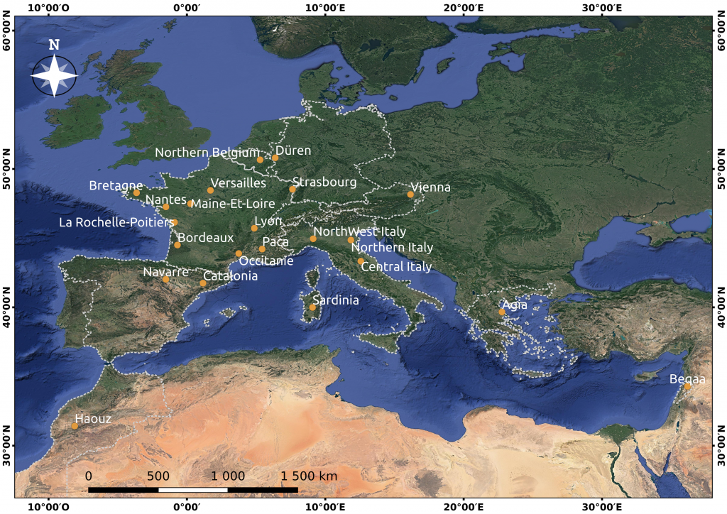
Location of the 22 sites documented by Theia VHSR Soil Moisture maps (September 2021).
Data access
Soon to be released. For now use the thisme portal
Contact
 Nicolas Baghdadi
INRAE | Tetis
ResearchGate
Nicolas Baghdadi
INRAE | Tetis
ResearchGate
 Mehrez Zribi
CNRS | Cesbio
ResearchGate
@M.Zribi
Mehrez Zribi
CNRS | Cesbio
ResearchGate
@M.Zribi
Team
 Ghaith Amin
INRAE | Tetis
LinkedIn
Ghaith Amin
INRAE | Tetis
LinkedIn
 Hassan Bazzi
INRAE | Tetis
ResearchGate
Hassan Bazzi
INRAE | Tetis
ResearchGate
 Mohamad El-Hajj
INRAE | Tetis
ResearchGate
Mohamad El-Hajj
INRAE | Tetis
ResearchGate
 Loïc Lozac’h
INRAE | Tetis
@L.Lozach
Loïc Lozac’h
INRAE | Tetis
@L.Lozach